Showing posts with label missouri. Show all posts

Friday, July 26, 2013

Get Into The Flow: Amidon Memorial Conservation Area

The Castor River Shut-Ins of Amidon
Gorgeous. Absolutely, unequivocal beauty. That is what I honestly think about the Castor River Shut-ins area of the Amidon Memorial Conservation Area. In fact, I'm not sure those words can even do it justice, we may need to come up with a new word, just to describe the beauty of the flowing waters and brilliant pink granite rocks that are found there.

In order to get to the lot that contains the trail head for the Cedar Glade Trail, you'll need to take Route J east of Fredricktown, MO to Route W (make a right), then head East on County Road 208 (CR 208). CR 208 will turn into a dirt/gravel road while you ride along, so don't fear any toothless banjo players, but you should always keep your eye out for em', just in case... As you scoot down CR 208 you will come to a fork in the road, and in the middle of that fork you'll see a real grist stone from one of the old mills that used to be located on the land here, so take a second to park along the side of the road and take a peek, it is a pretty nifty piece of history. Once you're finished checking out the grist stone, take the fork to the left, County Road 253 (CR 253) and then look for a parking lot on your right, there you'll find the trail head of the Cedar Glade Trail that will take you to the Castor River Shut-ins. Did I confuse you? Then take a peek at this area map, it may help sort it out for you and, of course there is a map at the bottom of this post that will take you to the Google Maps version.

I swear Hyatt's smiling big here...
Now, the Cedar Glade Trail, a 1 mile long loop trail, has a bit of a Jekyll and Hyde personality to it. The Dr. Jekyll side, or the "good" side, is a beautiful, wide and well trampled trail that leads from the parking lot to the Castor River Shut-ins. The hike takes you through a forest of mixed hardwood trees, dotted with short leaf pine growth, you may notice some extremely large oak trees which have fallen over, root ball included on the sides of the trail. I don't know exactly what caused these mighty hardwood trees to topple, but they certainly were old growth. Keep an eye out for turkey, squirrel and deer as the area contains a decent population of them out here, we even observed the ever elusive domestic short haired cat, which sent ol' Hyatt (our border collie) into a frenzy. The Dr. Jekyll portion will finally empty you out at the Castor River Shut-ins and I'm sure you'll be just as impressed with the river as we were.

The smooth granite boulders of the shut-ins.
Here you'll see the Castor River as it carves through the baby's bottom smooth pink granite. The rocks are gorgeous and the river may even have a bit of a blue or green tinge to it, making the whole scene absolutely picturesque. As always, beautiful smooth rock and water are a combination for slips and falls, so watch your step as you traverse the pink granite boulders. After you have, lets say, dipped your toes into the free flowing Castor River and felt the warmth of the summer sun as you rest on one of the pink boulders, you should be ready to take on the last bit of the Cedar Glade Trail... The Mr. Hyde portion.

Photos can't do justice to the scenery here.
The Mr. Hyde portion of the trail is the more "difficult" in terrain, as you will be walking on some of the smooth (and most likely wet) granite rock surfaces and navigating a bit of a loosely packed rock trail that heads up in elevation. The trail here is not as well maintained and some of the rocks will slip from underfoot as you make your way up, however, the pay off is nearly as grand as the view of the Shut-ins was for the first portion, this portion of the trail offers an over look that provides a vantage of all that you just observed up close and personal. As you finish the loop, be sure to visit the restoration of the glades areas here, you'll find some beautiful wildflowers blooming in spring!

Now, it is a short trail, and when it ends you will most likely want more, we certainly did. But don't worry, there is more to explore at Amidon, remember that fork in the road from earlier. Well what do you think is down the right fork? I hope to write more soon on that right fork of Amidon, such as a little spot to swim called "Hippie Hole" and some free range exploring. So get your bathing suit ready and I hope you're not afraid of some crawdads and bit of river crossing in a car!!

More Information:
Amidon Memorial Conservation Area
Amidon Area Map


View Larger Map

Friday, July 19, 2013

White Water and Rock Hounding: Silver Mines Recreational Area

A view of the breached dam at the Silver Mines Recreation Area.
Here's another great site that I discovered on a field trip in college, the Silver Mines Recreation Area, which is part of the Mark Twain National Forest, is located near Fredricktown and Ironton, Missouri. This area is named, ever so aptly, for the abandoned silver mines that are found here that were mined from 1877 through 1946 by the Einstein Silver Mining Company. Given that the operation spewed tons of rocks (leavings or tailings) from deep within the Earth as the miners searched for their target minerals of silver, tungsten and lead, this is a relative Shangri-la for rock hounds, who come from far and wide, rock hammers in hand to see what treasures they may unearth from the rubble. But those who are not out to hunt for minerals and stones may be after a different type of thrill, the thrill they find on the St. Francis River, the thrill of the only true "White Water" to be found in the state. I knew that the sound of rushing water and the possibility of finding some rare minerals would certainly interest my wife and daughter... and I couldn't have been more right.

A dragonfly paused long enough to give me this shot.
There are actually two hiking trails here, I'll send you to the one that is on the South side of the St. Francis River, that runs near the "Air Conditioner" mine and the tailings from the mine operations the North side is every bit as beautiful and slippery as the South, I just love rock hounding). After parking the car (be aware there is a day use fee of $2.00 per vehicle here, place your payment in the envelope and slip it into the locked container) you will make your way across the concrete walkway then head to the right to begin your one mile hike up to the dam. This hike is absolutely stunning, with gorgeous granite and felsite outcroppings and stunning views of the St. Francis River marking the trails progression. Be careful though, the same granite and felsite rocks that are so interesting to look at and examine may be the same formation may cause your rear become painfully acquainted with the hard ground and said rock, as these rocks can become quite slippery after rain or covered in early morning dew.

A member of the "indigenous" population takes a sun.
As you continue up, past the scenic overlook (which was in some disrepair on our visits there), be sure to stop by the "Air Conditioner" Mine and have a seat, especially on a hot Midwestern summer day! The air that comes from the mouth of this abandoned mine is more than cool enough to invigorate you for the rest of your short hike to the dam. You may not always be able to take a seat here though, as the available space at the mouth of the mine may be flooded with a foot or more of water, depending on the last time it rained in the area. Soon after taking a cooling break you will reach an area that is just pure rock, these are actually all tailings, from the mining of the area. This is a GREAT place to stop and begin exploring the different types of rocks and searching for some rare silver, quartz, or even small fragments of various gemstones.

Yes. That's a scorpion. In Missouri...
While you are exploring the abandoned tailings for interesting rocks and formations, BE CAREFUL! The native inhabitants of the area, which include snakes and small scorpions, may be hiding underneath rocks as you overturn them, use a stick... Please. This is the only place I have ever been, in Missouri, that I have actually found a scorpion (see the photo). I found this scorpion by picking up a rock, mere centimeters in front of its "face" and was beyond lucky not to have been stung. On a separate note, I believe that purple mineral found on the rocks there is flourite, and you'll find a great deal of that in the rocks here. Also be careful on the loose rock, period. It may shift at anytime and send you sliding down the hill. An amateur geologist also presented us with this small bit of knowledge (I can't vouch for the accuracy of it though), if you are looking for a bit of silver, most of it is contained in small veins you can find in the quartz rocks of the area. The silver here may appear dark or almost black to slightly silver metallic in color.

While rock hounding you may also keep an eye to the St. Francis River, particularly during the Spring, as you will undoubtedly be able to spot some crazy kayakers as they shoot out of the breach in the dam that used to span the river. These folks are amazing to watch and I've heard epic party details from when the American Whitewater Championships are in swing there during weekends in March. I never tire of watching the kayaks slice the water and navigate down the river through the dam.

Overall this is one of my favorite spots to visit and I certainly hope I didn't scare anyone with the shifting rocks, slippery outcrops, snakes and scorpions (dangers exist in all of the great outdoors), there is just so much to see and do. The whole family enjoys looking through the rocks, searching for that next shiny little "gem" and the wildlife certainly can keep you on your toes. When you couple that with magnificent views, a mine that can provide you a bit of A/C, a cooling river that you can take a wade in (but be careful of the current and dropoffs) and some wonderful plants and rock outcrops to explore, it's hard not to have a great family time!
All the action can exhaust even Hyatt, our border collie... And that's TOUGH!
Thank you for reading and, as always, let me know if you have any questions about the area or any experiences you would like to share! If you're "digging" (like the rock hound inference there?) the blog, be sure to give it a +1G up there and subscribe by just putting in your email address, you won't be bothered unless a new post goes up...

Happy trails and watch where you step!

More Information:


View Larger Map

Other Nearby Parks/Recreational Areas:


Friday, July 12, 2013

The Darn Near Perfect Hike: Pickle Springs Natural Area


Anyone who has hit the trail with their family knows, it isn't always perfect; someone usually is a bit tired, or a bit sore, or a touch cranky, or the weather may turn and sometimes the full beauty of the area (and the hike) simply isn't really revealed. However, I remember Pickle Springs to be darn near perfect and it would be this trip that truly solidified our family's love and appreciation of the outdoors and hiking. The weather, combined with the natural beauty that Pickle Springs Natural Area offers washed over each of us resulting in our family fully enjoying every single second of this hike, eager and excited to find what would lay around the next bend of the trail. I have a feeling, that if you time it just right, you too can experience a bit of that euphoria as well!

A small, but beautiful, group of Bird's Foot Violets
we found along the trail.
We ended up at Pickle Springs Natural Area simply by chance, that day we actually were looking to hike through Hawn State Park and the White Oaks Trail, but passed by the entrance and then turned into Pickle Springs Natural Area parking lot in order to reverse direction and head back. But instead of pulling back out of the lot, we decided to take a quick peek of Pickle Springs, and boy, am I glad we did! The two mile loop, "Trail Through Time", has just about everything that you could possibly pack into one trip; seasonal waterfalls, awe inspiring overlooks, incredible rock formations, ancient weathered trees, gorgeous wildflowers, babbling creeks, crystal clear spring water and so much more, all on an easy to navigate and well maintained trail that even features wooden bridges to help you over some troublesome creek crossings. The area was named a National Natural Landmark in 1974 and with so many unique features you will quickly realize why as you hike.

Ferns abound in the wet sandstone soil here.
As we began our trek, we opted to head right on the trail, toward Piney Glade, Rockpile Canyon and the Headwall Falls. It was quickly apparent to us that this trail was very well traveled, well packed with a bit of gravel thrown in for measure. The canopy of trees provided just the right amount of sunlight and warmth as we made our way through the forest and provided a perfect scene as the birds sang in the background. Headwall Falls were not really "Falling" but it was still an impressive formation of rocks and with frogs and toads abounding in the area my daughter had the time of her life chasing them about. I marveled at the ferns and mosses growing on the sandstone surface of the canyon while the steady beat of the water as it trickled off the edge and fell to the rocky floor where it would water a great gathering of lush green plants.

A pickerel in the hand is worth two in the spring...
Pickle Spring is itself an impressive sight, with the clear water flowing, while more water cascades over top, creating a mini-waterfall into the spring pool. The view from the bridge crossing the creek provides a perfect vantage of the spring and may even serve as a great place to dangle your toes into the water, Andy Griffith style. Here we found a great gathering of pickerel frogs who seemed to hop right into our hands! Continuing through it was a short trip up to Dome Rock, marked with so many shallow caves and crags, this rock just begs to be looked at closer.

Gathering inspiration at the Spirit Canyon overlook.
As you reach Spirit Canyon you will find Missouri's only native pine tree, the short leaf pine, growing in this area, along with white and black oak trees and many of these trees were growing as Missouri was thrown into the Civil War, according to the Missouri Department of Conservation. You may even chance upon a low blueberry bush, as they grow well in the somewhat acidic soil of the area here, if your lucky! As you actually step up to take in the Spirit Canyon view, know that this may be the best views I have experienced in my Missouri hikes, period. There is nothing "fancy" about the view, and I can't put my finger on exactly why I love this particular vantage point, but it has stayed with me and I can still picture it now in my head.

A view of the Double Arch, you can spend a great deal of time
here just snapping photos!
We continued to enjoy the hike, as it meandered near Bone Creek, crossing over the twin bridges and high crossing. Then as we neared the end of the loop we encountered some of the most interesting rock outcrops and formations I have seen. We "squeezed" through the keyhole and made our way past the Cauliflower Rocks, to the Double Arch and, if you're looking to take pictures be sure to save a few for here, as we spent a great deal of time right here, snapping away. As we finished our posing and preening for photos, we made our way out through The Slot and all walked back to the car with smiles I thought may need to be surgically removed.

According to many other hikers, the trail takes about an hour to complete, however, we took nearly two. With so much to see and so many places to spend "just one more minute" taking pictures it is easy to extend the traditional hiking time, and these days that time, spent with family having a great time, is overtime I look forward to and can't wait to do again.

I hope you enjoy the blog, let me know if you have any questions and thanks for reading!

More Information:
Pickle Springs Natural Area Website
Pickle Springs Topographic Map
 

View Larger Map

Friday, July 5, 2013

Going On A Treasure Hunt: Geocaching!


Adding a geocache search, or two, or three can
add even more excitement to your hike!
While I was typing up the paragraph on our search for the geocache on the Peewah Trail in Trail of Tears State Park, I was reminded of just how much fun we have, as a family, searching for these little bits of hidden treasure. I'll admit, even as a supposedly full-grown adult, my eyes light up just as much as my daughter's each time we find a geocache, and I'm always anxious to see what is inside! My daughter enjoys trading out one of her trinkets for one of those contained within the cache, while my wife and I most enjoy looking through the log, noting where all those who found the container before us are from while we marvel at just how wide this community has become. Since our family enjoys searching for these hidden gems and we love to see the community get a bit larger and the logs contained within the caches grow and grow, I figured that I should write up a little bit more than a simple paragraph on what geocaching is and how you can get in on the fun too!

So, I guess I should start with the basics. Geocaching is, for the lack of a better description, a world-wide treasure hunt, where you navigate to specific GPS (Global Positioning System) coordinates in order to find hidden containers that may be as small as a pill bottle to larger containers the size of a metal ammunition box. Now, if you're like me, that GPS coordinates line is staring you in the face... It's saying, "Hey bub, this is complicated, you need to have expensive GPS equipment if you want ANY chance of finding a geocache." But here's the deal, that smart phone you carry, the one that has the GPS chip built in, can get you within 10-20 yards (or closer) of any GPS coordinates out there, and better yet, you didn't have to spend an extra dime! In addition to your GPS device or phone, you'll need to have a pen (for autographing the log) and maybe a trinket of some type to trade. Now, on to apps for the smartphone crowd.

For Android users the best I've seen available (remember this is all personal opinion) is CacheSense, which is available in a 30 day demo form at CacheSense Demo, now, there are others available just hit up Google and search for something along the line of "best apps for geocaching" followed by what type of phone or mobile operating system you use. For iPhone (and android operating system) I found the Geocaching by Groundspeak to be very beginner friendly and fairly easy to operate, but again, there are many out there, so don't take my word for it. One big minus for me on the whole Geocaching app by Groundspeak is that it's nearly $10 for the app, that seems pretty steep, but it integrates seamlessly with their site. I would just suggest that whatever app you use have an "offline" mode, so that you won't lose your geocache just because you lost your signal. Then it is a simple as either manually plugging in the coordinates of the geocache or downloading a file from a website such as Geocaching.com. If you use Geocaching.com to get your information from you will need to make an account, it only takes a second and its free.

So, while you're on Geocaching.com simply move your mouse cursor over the "Play" button on the menu bar, then select "Hide & Seek a Cache". The page there is pretty darn self explanatory, type in an address, a zip code, state or other area and click on the "Go" button. When we first began, we only did caches that were easy, and we started on a public trail near our home so the walking was easy. So once you've picked out your first geocache target, find the coordinates for your anticipated treasure hunt and enter them into your GPS device or app! All that's left now is for you to get on out there and find that cache.

Once you've found the cache (congratulations by the way!) be sure to sign the log book or log sheet and take a second to look at the names and locations of the fine geocachers that have found the cache before you. If you'd like to trade out for an item that is contained in the cache, well, I hope you brought something along with you, because the rules are, whatever you exchange should be of equal or greater value that that which you take. We really dig taking a few of the little figures you find in the $0.50 machines in supermarkets and such, we've also found that these are taken pretty darn quick, especially zombies for some reason. So, once you've signed the log and traded for a bit of something, or maybe just took a picture of the contents, you may want to log the your geocache find online at Geocache.com. Here is a short video on how to log a geocache once you've found it:


I hope all this helps and I'm sure that adding a geocache or two on your next hike will pay back in TONS of fun, just be remember to bring a pen and perhaps a trinket to trade with you. Let me know if you have any questions or want any additional information and, as always, thanks for reading and happy trails!

More Information:
Geocache.com - A great source information of all things relating to geocaching, a must hit for anyone looking to start!
Top Five Android Geocaching Apps - You don't have to take my word for it
Top 6 Android Geocaching Apps - In case you don't want to take my word or the link above's word...
Top 5 iPhone Apps For Geocaching - for the iPhone folks

If you like what you're reading, please share it with others. Look below there, hit up the G+1 or share this blog on facebook, twitter or who knows... Cheers!

Wednesday, July 3, 2013

Trail of Tears State Park II: Peewah Trail


After experiencing the beauty of Trail of Tears State Park while exploring the three mile Sheppard's Point Trail, we knew that our family would be heading back soon, this time to tackle a more "formidable" foe... The nine mile long Peewah Trail. Now, I say that the Peewah Trail is ten miles, and it is, but the beauty of this trail is that it is split into two completely different trails with two seperate trail heads, that forms a full on (if a bit askew) figure eight. These two sections of the Peewah Trail are simply referred to as the East Loop and the West Loop.

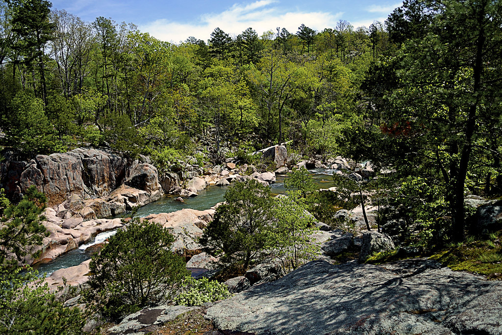
The "boys", Hudson (brown & white) and Hyatt, taking in a quick refresher
from one of the numerous creek crossings on
the East Loop of the Peewah Trail
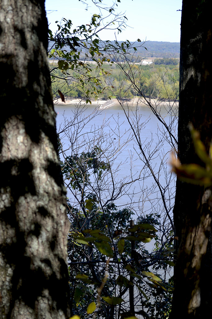
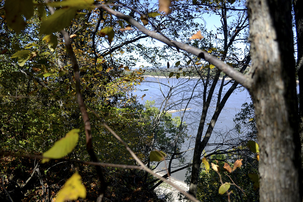
The East Loop: The East Loop is approximately 3.25 miles long and is easily identified by its yellow blazes. This loop climbs the ridges and bluffs that overlook the Mississippi to the East and even features a small spur that will take you out to a scenic overlook (located 1.5 miles East of the trail head for the East Loop) so that you can get a beautifully clear picture of the Mighty Mississippi, in fact, if you find that the scenic overlooks just off the roadside are full, this viewpoint and the vantage at Sheppard's Point are excellent alternatives, and all but guaranteed to be less crowded during Bald Eagle season. This trail is a perfect example of what goes up, must come down. As you follow the bluffs and ridges along the Mississippi eventually you'll come to the descent into the bottom-land, filled with wildflowers (in the spring/summer), giant cane and even a few creek crossings. Of course, with the creek crossings the possibility of washouts and flooding are a possibility depending upon the level of the Mississippi, so pay attention and use caution during any creek crossing. As you are on the Western side of the loop, keep an eye out for the black and white blaze, indicating the connector between the East Loop and the West Loop.

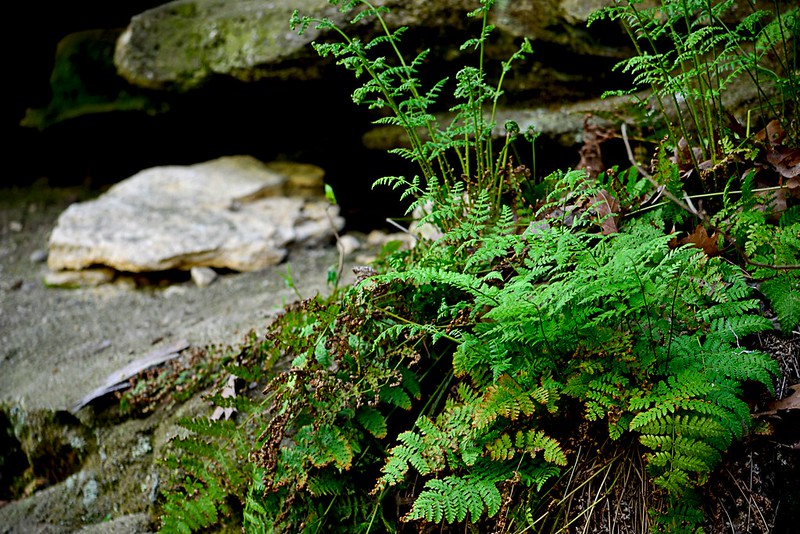
Twisted and snapped trees can be found
from the 2003 tornado damage.

The West Loop: To access the 5.75 mile long West Loop, you may hit the trail head, located along the Overlook Road, just north of Hill Road or you can hit the connector from the East Loop, mentioned above. As you hike through the region, marked clearly with red blazes, you will notice areas with beautiful oaks and hickories lining the ridgetops, while sweet gum and sycamore dominate the bottom-lands, with a health amount of native ferns thrown in just for measure. While taking in the beauty of these trees you may encounter areas that appear to be "stunted", but they are not, we had a tornado ravage the area in 2003 and this trail shows the clear evidence of the tornado's path. This is a perfect way to teach the destructive powers of a tornado, as the downed and twisted trees are still easily seen from the trail. Of course for a child, these downed trees provide a perfect and fun opportunity to increase their climbing skills too! This damage is a great example of the resiliency of the forest when taken care of.

Searching for
Now, for our family this was a pretty long hike and in order to spice up the nature for my then ten-year-old, we decided to search for a few geocaches while out on the trail. If you are unfamiliar with geocaching, or think I just made it up, head over to Geocaching-The Official Global GPS Cache Hunt Site for all the information you could ever want, and a quick and easy look up for geocaches near you or your prospective hikes. For our hunt, we simply took our car GPS unit into the field with us and used the coordinate look-up function to place the marker on our screen, of course your unit may be entirely different, but the fact is, we didn't need a fancy pants hand held unit and nearly all smart phones have a GPS function built in and numerous apps are available for you to use, such as the Geocaching Toolkit, I have used this one myself so I can vouch for it. Keep in mind, there is a Geocacher's Code of Ethics and be sure to bring along something to trade for an item that you may find interesting, be sure to read where others who have come before you are from, it is interesting to find so many others who found your little "secret" stash! Another quick note as you look over the geocache entries, a "Muggle" is someone that isn't out to find a geocache or someone unaware of geocaching even exists, I'm not a big fan of the Harry Potter series and it took me a bit to figure out what the heck a muggle was.

The West Loop has a few creek crossings as well, Indian Creek is prone to flooding its banks and flash flooding is always a possibility during rain storms, so please be careful as you cross these areas. As with any area rich in water and cover, there is a great chance to spot wildlife on both trails, keep an eye out for turkey, whitetail deer, foxes, fat little squirrels and more. Concerning the squirrels, keep an eye on the sky, as we were convinced that one particularly fat little bugger was chucking branches and nuts at us, funny till you catch one on the noggin.

You may notice on the Peewah Trail Map that the West Loop is nearly bisected by trail that leads to a backpack camp located dead center of the loop. We did not explore this camp, but I can assure you, we fully plan to! In fact, we hope to use this as a refresher before taking on some longer backpacking trips this fall and next spring, so stay tuned for more information as we experience it.

Overall both trails offer fantastic hiking, well maintained and clearly marked trails (provided you know what you are looking for, so please print out a map), some breathtaking views and scenic spaces. We only encountered one other group of people out on the trail, another family, and immediately after they were out of earshot we were instantly transferred back into the solitude and serenity of the wild acres. The boys enjoyed all the smells and nature along the trail, while we enjoyed the family togetherness you can only experience on a hike. Even though we went during the late fall/early winter period there was still PLENTY to see and take note of, however, this trail would be truly breathtaking in early fall as the leaves change and the bottom-lands truly come alive in the early spring with a plethora of local wildflowers in full bloom at that time. I certainly hope you'll make time to explore at least one of the two loops available on the Peewah Trail, I'm sure you'll find it just as enjoyable as we did.

As always thank you for reading and let me know if you have any questions on the trail. If you dig the blog be sure to give it a +1 up there or subscribe with your email address up top, it won't bug you until the next update then. Happy trails till next!

More Information:
Flickr Gallery of Shots
Click here for Peewah Trail Map
Click here for Trail Listing in Trail of Tears State Park
Trail of Tears State Park
429 Moccasin Springs
Jackson, MO 63755-8295
(573)290-5268(573)290-5268


View Larger Map

Sunday, June 30, 2013

Hike Through History: Trail of Tears State Park and Sheppard's Point Trail

Trail of Tears State Park, to me, is that "homely" girl in the sappy love movie. You know the one that no one pays any attention to and calls a geek, then, suddenly, she lets down her hair and takes off her glasses to reveal she's smokin' hot! For me, that is the tale of Trail of Tears State Park and this gal seems to have something for everyone: fishing, swimming, horse trails, picnicking, camping, backpacking, beautiful scenic overlooks, bird watching (people "flock" from all over to watch the Bald Eagle migration), Mississippi River access, hiking and so much more!


Now, I am no stranger to Trail of Tears, in college, friends and I would escape our campus confines and seek out the coolness of Lake Boutin for a dip or cast of the line, while partaking a few tasty cold beverages and observing the local bikini-clad "wildlife". Here's a quick note to those that may wish to also take a dip in Lake Boutin, wear shoes or water socks. There are still some old school pop tops (I put in this picture link because I realized a lot of folks may have no idea what that is) buried in some of the sand here so protect those tootsies! However, I was a trail virgin to over thirteen miles of pristine and well maintained trails the park harbored and after a quick internet search found that the three mile Sheppard's Point Trail could be a great "go to" hike for me and the family!
The parasitic beech drop.
Photo found on Wikipedia

Trail  of Tears State Park is very, very well marked and navigating from place to place within the park is very easy and directions are clear and evident. Upon arriving at the Sheppard's Point Trail Head, we noticed a few other cars, but we would never spot our fellow trail hikers (or hear them for that matter). We unloaded and leashed our "boys" Hudson and Hyatt, snatched our water bottles from the cooler, tightened up our laces and hit the dirt trail that headed straight into the hardwood forest. As we hiked, white oak, American beech, cucumber magnolia and beautiful tulip poplars lined the trail, as the dirt path took us to the tops of ridges and into deep valleys. Beneath the trees we saw brilliant green ferns and I took special note to look out for a rare plant, the parasitic beech drop, siphoning nutrients from the roots of the American beech.

The trail itself has some condition issues in spots (holes and root growth) and can be steep in places, but each incline of the trail is slowly adding up to one heck of a view! Nearly halfway through the hike is an awe inspiring vantage of the Mississippi River and a perfect place to take a quick rest and recharge while watching barges and tugboats navigate the mighty (and muddy) river. This point is also a prime observation point for bald eagles, particularly during the winter months. Also watch out below, there are some great drop offs that you can perch on to garner an even better view of the river, or peer directly over the edge to watch trains travel with their goods along the rails below.

After taking our break and watering both ourselves and the boys, we began to complete the Sheppard's Point loop and once back at the car, we all found that the trip was beyond enjoyable, if not a bit rough traveling up and down though. It seems as though we would be back, and soon to take a trip on another Trail of Tears hiking route... The Peewah Trail.

More Information:

Sheppard's Point Trail Map

Trail of Tears State Park
429 Moccasin Springs
Jackson, MO 63755-8295
(573) 290-5268(573) 290-5268


View Larger Map