Showing posts with label Natural Area. Show all posts

Wednesday, September 2, 2015

Cache River State Natural Area: Todd Fink-Heron Pond


A Zipper Convergence

See that cool "Zipper" effect?
This short, 1.5 mile, trail begins simply enough. You'll find yourself descending into a mix of hardwood forest comprised of a mix of oak, hickory and sweet gum. As you reach the bottom of your descent you will come to a small truss bridge over which you will make your way over a convergence of Dutchman's Creek and the Cache River. If you find yourself crossing this bridge without setting an eye just upstream, toward the actual meeting of these two streams of water, you are missing a truly magnificent sight. For it is here, just upstream, where the relatively clear waters of Dutchman's Creek and the rich muddy flow of the Cache River slowly merge, becoming one, but not before the waters dance together, swirling and circling, ebbing and flowing, creating an absolutely hypnotic effect. The trail continues on just the other side of the bridge, and closely follows the snaking trail of the Cache River. As you continue your hike you will find a fork in the trail, it is here that you will want to journey to the left and in just a few short yards you will find the Heron Pond boardwalk.

Down On The Boardwalk

The Heron Pond boardwalk winds its way out and into the very heart of its namesake pond. The waters here were more clear than we found at the Section 8 boardwalk, which allowed us glimpses of turtles, fish, insects, frogs and more as they swam among the giant tupelo trees and "knees" of the cypress here. In areas we found duckweed would obscure our little windows into the private underwater world of the swamps residents, occasionally these serene green mats of aquatic carpet would erupt with a violent "POP" as an underwater assassin would hungrily burst through the thin layer of duckweed in pursuit of an insect.

But Wait! There's More!

Now, after you've taken the journey on the Heron Pond boardwalk you may think that's it... But you'd be wrong. Remember that fork, where we turned left? You may be wondering what exactly would have happened had we turned right instead. Well let not your heart be troubled, because had you turned right at that fork you would have taken a trail that would have led you directly to yet another state champion tree! This time you would have discovered the state champion cherrybark oak tree that has grown to a circumference of over 22 feet and 100 feet high! You may never have quite so much fun feeling so very, very small and believe me, it's worth a quick visit to set your eyes upon this towering titan, plus it is only a few yards up that right path...

Directions


More Information:


Local Treks on facebook 
Cache River State Natural Area: Much More Than Mud & Muck - An overall view of Cache River State Natural Area
Cache River State Natural Area: Big Cypress Tree Trail - Looking for the state champion bald cypress? Take this trail!
Cache River State Natural Area: Section 8 Nature Preserve Boardwalk - Take a stroll directly through a swamp without even getting your feet wet!
Cache River State Natural Area homepage 
Hiking Maps of the Area
Barkhausen-Cache River Wetlands Center
Cache River State Natural Area Map
Color Brochure of the Area

Cache River State Natural Area: Big Cypress Tree Trail

What Is the Cache River State Natural Area?

The Cache River State Natural Area is an absolutely stunning example of a well restored wetlands area. You will find this gem nestled within a floodplain, which was sculpted by the mighty flood waters of the Ohio River ages ago. The Cache River Wetlands is now fed by the Cache River and it's many tributaries and stretches over 14,960 acres in Johnson, Massac, and Pulaski counties in Southern Illinois. This scenic area also plays as a featured stop to many migratory bird species, including bald eagles, great blue herons and (a personal favorite) snowy egrets. In addition to the myriad of migratory birds you will undoubtedly catch an earful of the areas most vocal inhabitants as choirs of spring peepers, bullfrogs, bird-voiced tree frogs, American toads and more amphibians all sing together from the bogs to the boughs and everywhere in between. As you hike on the trails and boardwalks below you may also want to keep a keen eye trained for some of the larger warm blooded residents as many white tailed deer, squirrels, raccoon, beavers, foxes and mink call the area home as well.

A Short Trail, Big On Visuals!

Beyond the wildlife that inhabits the Cache River State Natural Area, the area also boasts some truly spectacular plant life. Throughout the area you will discover ancient cypress trees with their flared bases and many "knees", which were mere saplings over 1,000 years ago, now standing sentinel over the rich, black-water swamps that still nourish them. On the short, 250 foot Big Cypress Tree Trail you will find one very special bald cypress. This particular cypress tree has been so nourished by the rich waters that it has developed a remarkable base (also referred to as a buttress) of over 40 feet in circumference and towers over 73 feet tall, which has earned it recognition as a state champion. As you make your way to the enormous namesake of this trail over the pavement, be sure to take note of the other plants such as majestic tupelo trees and low lying thickets of button-bush that share the landscape with the silent cypress colossus.

You may even catch sight of some fellow nature lovers out paddling among the giant trees. Many come to the area and take paddling tours, which offer additional advantages here in the wetlands. There are local businesses that can even take you on a guided tour of these impressive swamps!

Directions


More Information:

Local Treks on facebook 
Cache River State Natural Area: Much More Than Mud & Muck - An overall view of Cache River State Natural Area
Cache River State Natural Area: Section 8 Nature Preserve Boardwalk - Take a stroll directly through a swamp without even getting your feet wet!
Cache River State Natural Area: Todd Fink-Heron Pond Trail - Another state champion tree and awesome boardwalk trail!
Cache River State Natural Area homepage 
Hiking Maps of the Area
Barkhausen-Cache River Wetlands Center
Cache River State Natural Area Map
Color Brochure of the Area

Friday, July 12, 2013

The Darn Near Perfect Hike: Pickle Springs Natural Area


Anyone who has hit the trail with their family knows, it isn't always perfect; someone usually is a bit tired, or a bit sore, or a touch cranky, or the weather may turn and sometimes the full beauty of the area (and the hike) simply isn't really revealed. However, I remember Pickle Springs to be darn near perfect and it would be this trip that truly solidified our family's love and appreciation of the outdoors and hiking. The weather, combined with the natural beauty that Pickle Springs Natural Area offers washed over each of us resulting in our family fully enjoying every single second of this hike, eager and excited to find what would lay around the next bend of the trail. I have a feeling, that if you time it just right, you too can experience a bit of that euphoria as well!

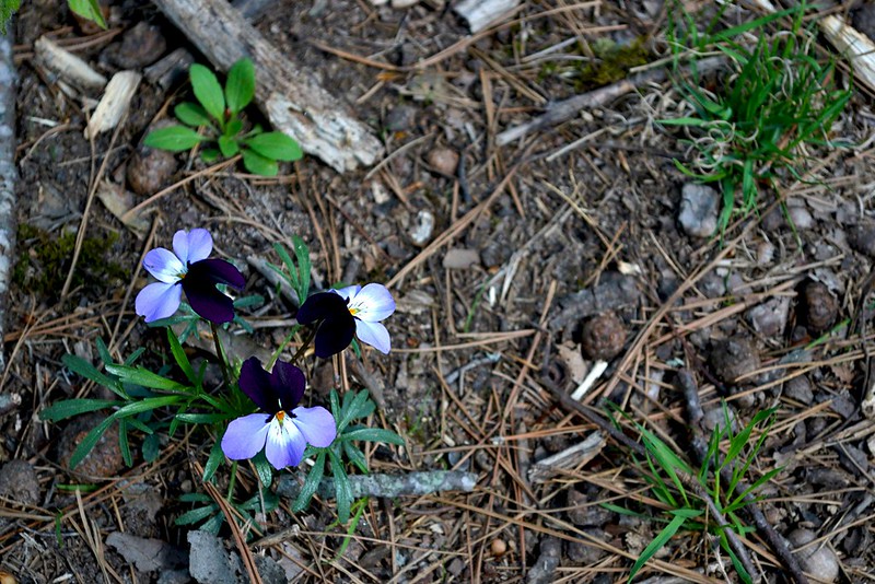
A small, but beautiful, group of Bird's Foot Violets
we found along the trail.
We ended up at Pickle Springs Natural Area simply by chance, that day we actually were looking to hike through Hawn State Park and the White Oaks Trail, but passed by the entrance and then turned into Pickle Springs Natural Area parking lot in order to reverse direction and head back. But instead of pulling back out of the lot, we decided to take a quick peek of Pickle Springs, and boy, am I glad we did! The two mile loop, "Trail Through Time", has just about everything that you could possibly pack into one trip; seasonal waterfalls, awe inspiring overlooks, incredible rock formations, ancient weathered trees, gorgeous wildflowers, babbling creeks, crystal clear spring water and so much more, all on an easy to navigate and well maintained trail that even features wooden bridges to help you over some troublesome creek crossings. The area was named a National Natural Landmark in 1974 and with so many unique features you will quickly realize why as you hike.

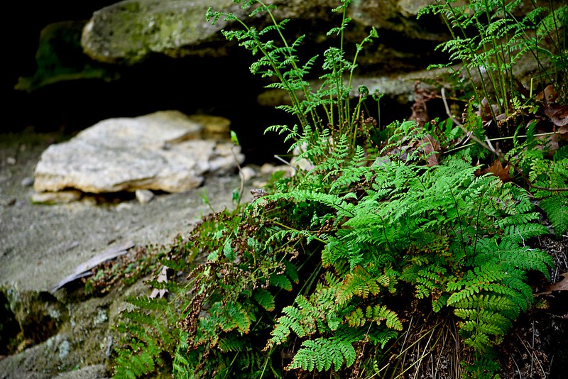
Ferns abound in the wet sandstone soil here.
As we began our trek, we opted to head right on the trail, toward Piney Glade, Rockpile Canyon and the Headwall Falls. It was quickly apparent to us that this trail was very well traveled, well packed with a bit of gravel thrown in for measure. The canopy of trees provided just the right amount of sunlight and warmth as we made our way through the forest and provided a perfect scene as the birds sang in the background. Headwall Falls were not really "Falling" but it was still an impressive formation of rocks and with frogs and toads abounding in the area my daughter had the time of her life chasing them about. I marveled at the ferns and mosses growing on the sandstone surface of the canyon while the steady beat of the water as it trickled off the edge and fell to the rocky floor where it would water a great gathering of lush green plants.

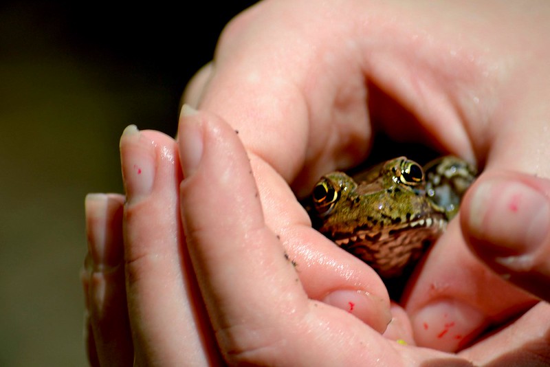
A pickerel in the hand is worth two in the spring...
Pickle Spring is itself an impressive sight, with the clear water flowing, while more water cascades over top, creating a mini-waterfall into the spring pool. The view from the bridge crossing the creek provides a perfect vantage of the spring and may even serve as a great place to dangle your toes into the water, Andy Griffith style. Here we found a great gathering of pickerel frogs who seemed to hop right into our hands! Continuing through it was a short trip up to Dome Rock, marked with so many shallow caves and crags, this rock just begs to be looked at closer.

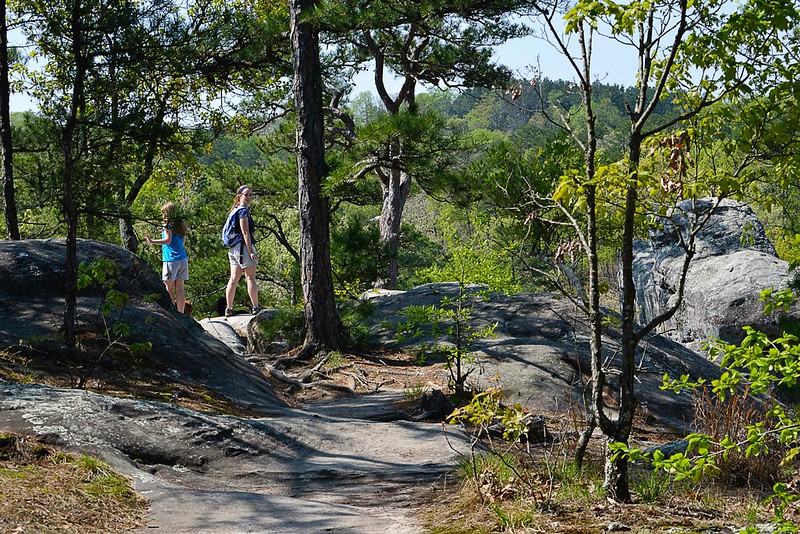
Gathering inspiration at the Spirit Canyon overlook.
As you reach Spirit Canyon you will find Missouri's only native pine tree, the short leaf pine, growing in this area, along with white and black oak trees and many of these trees were growing as Missouri was thrown into the Civil War, according to the Missouri Department of Conservation. You may even chance upon a low blueberry bush, as they grow well in the somewhat acidic soil of the area here, if your lucky! As you actually step up to take in the Spirit Canyon view, know that this may be the best views I have experienced in my Missouri hikes, period. There is nothing "fancy" about the view, and I can't put my finger on exactly why I love this particular vantage point, but it has stayed with me and I can still picture it now in my head.

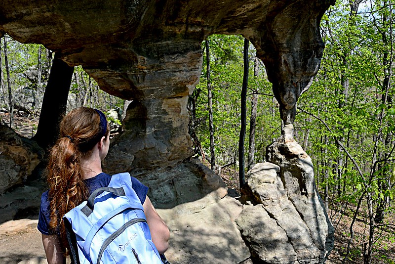
A view of the Double Arch, you can spend a great deal of time
here just snapping photos!
We continued to enjoy the hike, as it meandered near Bone Creek, crossing over the twin bridges and high crossing. Then as we neared the end of the loop we encountered some of the most interesting rock outcrops and formations I have seen. We "squeezed" through the keyhole and made our way past the Cauliflower Rocks, to the Double Arch and, if you're looking to take pictures be sure to save a few for here, as we spent a great deal of time right here, snapping away. As we finished our posing and preening for photos, we made our way out through The Slot and all walked back to the car with smiles I thought may need to be surgically removed.

According to many other hikers, the trail takes about an hour to complete, however, we took nearly two. With so much to see and so many places to spend "just one more minute" taking pictures it is easy to extend the traditional hiking time, and these days that time, spent with family having a great time, is overtime I look forward to and can't wait to do again.

I hope you enjoy the blog, let me know if you have any questions and thanks for reading!

More Information:
Pickle Springs Natural Area Website
Pickle Springs Topographic Map
 

View Larger Map