Showing posts with label map. Show all posts

Monday, March 10, 2014

Panther Den: Don't Forget Your Map!

Local Treks: Panther Den Wilderness Boundry Sign

Panther Den Wilderness may be the smallest wilderness area in the state of Illinois, but it packs in some of the most distinctive and maze-like rock formations you may ever see! This distinctive and unique area boasts over 820 acres of land and is bordered by Crab Orchard Wilderness, which offers an additional 4050 acres of Illinois wilderness to its north. Before you read on, you may want to brush up on Wilderness Areas (Let's Get WILD) is and print yourself off a map of the area.

How To Get There
Finding Panther Den Wilderness may be, in itself, a bit of an adventure. If you have been searching for directions I'm sure you've encountered a thousand different versions out on the internet. Some talking about private land others talking about washed out creeks, heck some may even be saying you'd better just float on in from the north on one of the fingers of Devil's Kitchen Lake. I guess I'll go ahead and add another way to get there, ours was simple and fairly straight forward.

From Cape Girardeau, MO we started across the Emerson Bridge into Illinois and followed highway 146 East through Anna, IL turning left on Lick Creek Road near the outskirts of town. After traveling about eight miles down Lick Creek Road, we veered off to the left onto Grandview Road, following it until again veering left onto Hall Church Road. Follow Hall Church Road until you are able to turn right on Rocky Comfort Road, enjoy this last bit of paved road. Continue down Rocky Comfort Road for about three miles until you can make a right turn onto Panther Den ROAD. Welcome to the gravel my friend! Now, follow Panther Den ROAD for a bit over a mile or so, until you see
Panther Den LANE on the left. You'll notice this road is in pretty rough shape (or at least it was in 2013-14), keep to the right as it is a one lane road, and you will see the parking lot at the end of the road on the right.
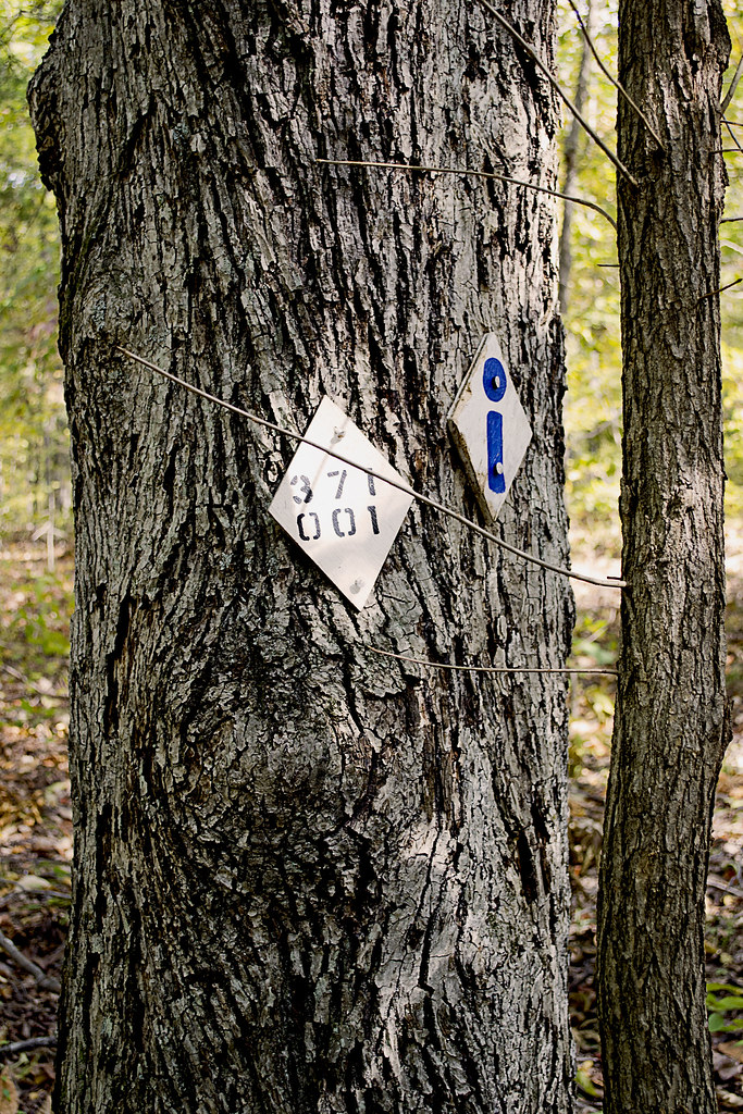
Local Treks: Panther Den Trail Markers 001 & 371
Pay attention to the trail markers out here:
The Panther Den loop is 389,
the trail back to the lot is 371,
and the River to River Trail is 001.
See the Quick Trail Note below.
The Trail
One of the first things you may notice as you approach the trailhead is that there is a complete lack of information and maps on the Panther Den Informational Board (or at least there was on all of our visits in 2013-14). I don't know if all the information fell off, was stolen, or if a pack of wild dingos with a taste for maps and information strolled in and devoured all postings. So be sure to print off a map of the area before you leave home, read my cautionary tales below if you don't think having a map is important...

The trail itself begins as a mixture of gravel and dirt, featuring many planned switchbacks which help to reduce the wear and tear of erosion on the trail and wilderness. The switchbacks also make the hilly terrain a bit easier to traverse. The rolling downhill hike will bottom out with a small creek crossing, be alert here as we have found this a fantastic place to find local wildlife visiting for a refreshing drink. From here you'll travel up a small hill be sure to veer left at the trail intersection and that will take you to a welcome sign for the area. You can now follow the trail around the Panther Den or, better yet, go inside the magnificent sandstone formations for which the entire wilderness area is named!

Quick Trail Note:
The Panther Den loop makes use of the 389 white diamond trail markers/blazes, however these markers are sometime sparse and, I suspect, stolen by idiots. You may see markers up for 389-A and 389-B, both of which are small spurs, these spurs seem to be old, abandoned trails. My experience is that 389-A and 389-B are generally overgrown and hard to navigate (I became pretty lost on what I believe now to be 389-B). I'd suggest staying on the main 389 trail and then following the 371 trail marker back to the parking area. 001 is the designation for the River To River Trail, which runs through and connects Panther Den Wilderness and Crab Orchard Wilderness.

Enter The Den!
Local Treks: A "Room" at Panther Den
One of the many "rooms" within the
Panther Den rock formations.
Inside Panther Den, you'll find these huge sandstone formations seem to form rooms, hallways, and even floors. Some of these formations are so angular that you may have an "Ancient Aliens" like feeling, wondering if perhaps some ancient astronauts visited the area eons ago in order to lay down rock foundations and rooms to inhabit. One particular "room" in Panther Den seems to even have a poured foundation. In reality though, aliens didn't have anything to do with it, all of the formations are natural... Or are they?

You can easily spend hours inside of Panther Den, leaping from cliff to cliff, poking into every crack and crag, squeezing through narrow crevices and splits or just running your hands over the smoothness of the sandstone. There are small waterfalls to be discovered, side trails to be explored, cairns to be constructed and plenty of places to hide as well; so you can jump out and scare the wits out of your friends and family. And, although you won't find any panthers in Panther Den (at least not since the 1870's) you may spot some other local wildlife such as whitetail deer, turkey, muskrats, beaver, and skunks. If you are really lucky, you may even get a rare glimpse of a bobcat or mink. So be sure to keep your eyes peeled!

Local Treks: Panther Den Meeting Cairn
Be sure to set a meeting place up.
Just in case.
You will also find many sandstone "coveys" carved into the rock in the area around Panther Den. These sandstone overhangs offer shelter to an uncommon wildflower, French's shooting star (Dodecatheon frenchii). Unfortunately we didn't spot a single one on any of our hikes. But, if you would like to see or find one I would suggest hitting the area in May or June and seeking out sandstone overhangs near running water. Although the French's shooting star is not currently on Illinois Threatened and Endangered list, it is still considered a sensitive species in the state. So if you are lucky enough to find a colony of these beautiful little wildflowers, please take only pictures so that others may be able to enjoy their beauty as well.

You may also want to stick together while exploring the inside of the formations, or at the least set a place and time to meet up in case someone gets separated. It is very easy to get lost within the maze-like formations of Panther Den. Children (and parents) may freak out if they suddenly find themselves separated from the rest of the group. If you become horribly lost remember that a distress signal in the woods consists of three successive sounds; be they yells, shots, claps, whistles, or any other signal.

Camping
There is so much to be explored in Panther Den that you may even consider camping within the area. If you do, remember that you are within a wilderness area. You do not need a permit and the US Forest Service asks only that you practice "Leave No Trace" ethics and camp a minimum of 300 feet from any established trails. Most of the "user" camps that you will encounter are far too close to established trails and have left obvious marks on the landscape. You are encouraged not to use these campsites so that these overused areas may recover. Of course, you may want to read up on what a wilderness is and always remember to practice your very best Wilderness Manners.

Now that I've told you of how beautiful and truly distinct Panther Den Wilderness is, I'd like to give you two quick stories of warning. 

Story One: Our First Trip
Local Treks: Panther Den Natural Hallway
On our first outing at Panther Den Wilderness we became lost. Very lost. Playing victim to many of the "trails" as we ventured further into the wilderness. We had inadvertently stumbled upon an old, abandoned equestrian trail that twisted and turned through rugged terrain. As I continued to notice the decline in the quality of the trail, I became (silently) alarmed. I could tell we were no longer on an established trail and we had taken so many lefts and rights, I could not recall from which way we had come. Luckily I had my phone, turned off, in my pocket. No bars. We continued to hike and I continued to quietly check my phone. A bar lit. I stopped and instantly hit the button for Google Maps. Once it loaded I found our heading and took note of where the trailhead was on that small, smart phone screen. Had it not been for that stroke of luck we may have been lost for hours in Panther Den Wilderness. This is the experience that taught me to never, ever, set out on a trail without a map and an idea of the route I wish to travel.

Story Two: Stranger on the Road
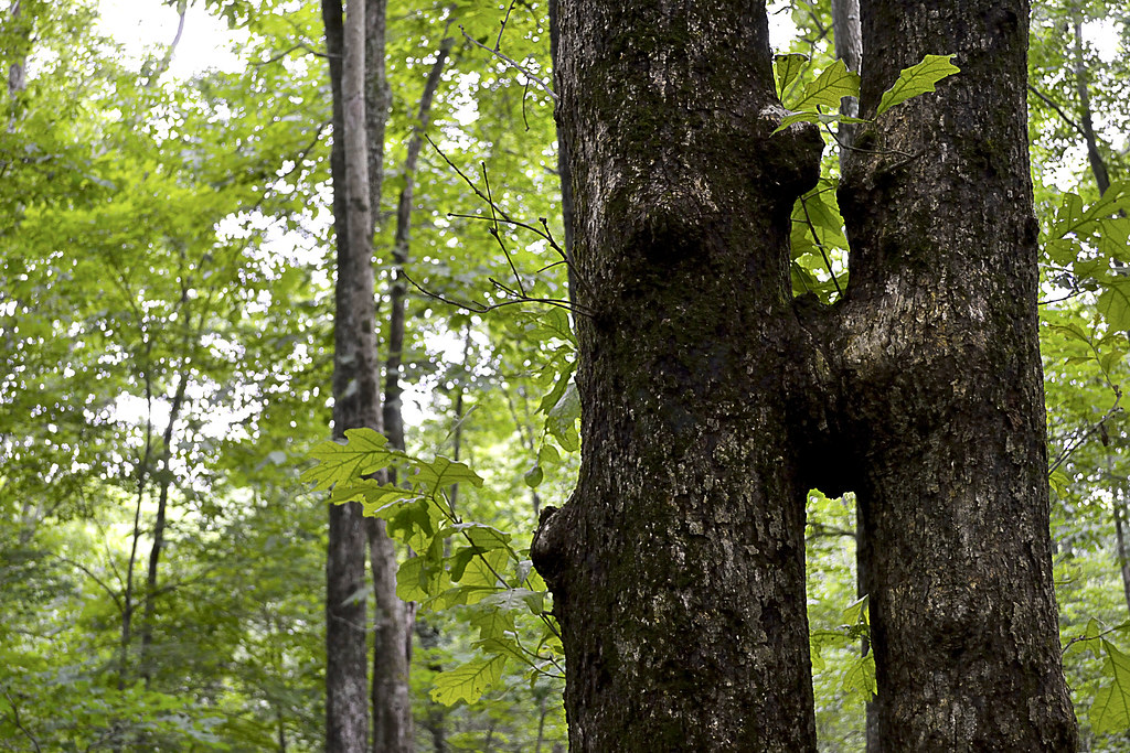
Local Treks: Kissing Trees at Panther Den
Panther Den Wilderness is for tree lovers...
On our second visit to Panther Den Wilderness we made our way down the gravel road toward Panther Den Wilderness, when we noticed a man wandering aimlessly nearly a mile from the trailhead. It was apparent to me that he was lost and I slowed down to see if he needed any assistance. He sheepishly admitted to us that he too had fell victim to one of the "false" trails of Panther Den and as we drove him back to the trailhead, he told us he had been wandering for hours, without a phone or map, happening upon the road by pure chance. I could tell he was embarrassed, as I had been just a few months prior, of becoming so lost. He was an outdoorsman, confident in his abilities to maintain a heading and follow a trail, it was this over confidence (which I too had suffered) that led to his unintended side adventure, and his catching a ride with us back to his truck. His last words to us were, "I can never let my wife know about this."

So now, please, take this map. Print it. Fold it. Put it in your pocket. It's simple. If you plan to visit Panther Den Wilderness and truly explore the area I cannot stress the importance of having a map on hand enough. Safely experiencing the beauty and sheer uniqueness of the area is worth the ink!


More Information:
CLICK HERE AND PRINT THIS MAP!
Visit Local Treks on facebook!
Wilderness Areas: Let's Get WILD!
Tips: How To Take A Great Dayhike  
Illinois Wildflowers (online guide with pictures)
A Conservation Assessment for the French's Shooting Star (warning: good read, pretty scientific)
National Geographic "Backyard Bird Identifier"
Wednesday, August 28, 2013

How To Take A GREAT Day Hike

Local Treks Hiking: Single Red Leaf

We've all been here. The TV weatherperson just called the upcoming weekend the "very best ever!" and the smiling sun graphic behind them has you wanting to get out, get in touch with nature, breathe in a bit of fresh air and nab some exercise while you're at it. If you're looking to hit every one of those points out of the park, get on out and take a day hike. If you follow a few simple steps, I'm sure you'll find that a day hike is simple, easy and TONS of fun.

Local Treks Hiking: Millstream View
Where do you want to go?

This is the most important question you can ask yourself before getting into the "meat" of your potential hike. Head to the internet and search your local state and national parks, or better yet read a review or two right here on the blog. If you haven't hiked much you may want to keep your hike short, seeking out 1-2 mile "loop" style trails, be sure to allow yourself plenty of time to soak in the beauty of your surroundings. A loop trail will make a circle and upon completion should take you right back where you started, at the trail head.It is always best to find a topographic map as well, be sure to look at the elevation as every mile hiked up 1000 feet will feel like three miles hiked flat.

Local Treks Hiking: Climbing Tree
Wear the right clothes.

I like to wear loose fitting clothes, not so loose that they may get in my way in an attempt to trip me, but loose enough that they don't bind me or feel restrictive when I walk, climb or scramble over rocks and boulders. If you want your clothing to run double duty for you be sure to wear light colored clothing, to help avoid ticks. You may also want to spray your clothing down with an insect repellent that contains 20% DEET or make your own homemade bug repellent to keep nasty insects at bay as well, keep in mind, insect repellant doesn't last forever, you'll have to re-apply (usually after 2-3 hours). You may find some good deals on outdoor clothing online, I've found some good deals at The Clymb (you'll need to register though).

Local Treks Hiking: Hiking Shoes
Wear the right shoes.

You don't have to wear hiking boots when hiking, in fact, I don't even own a pair. Personally, I prefer a pair of trail running shoes (or just regular tennis shoes), they are light, responsive and I've found that they grip the trail and rocks quite well. Just be sure that these shoes are comfortable and for the love of Pete, don't ever, ever, ever wear a brand spanking new pair of shoes or boots into the woods. You're begging for them to be ruined and get some wicked blisters as well, always be sure to "wear in" your shoes before really tackling any trail mileage.

Local Treks Hiking: Little Grand Canyon Trail

Find some hiking buddies.

If you're able, grab a few friends and take them with you, bonus points are given (but not rewarded) for nabbing up pals that are experienced hikers. Better yet hop on the Local Treks facebook page and see if anyone else is interested in meeting up! For my fellow hikers that love to take to trail with friends of the hairy and four-legged design, pay special attention when researching your hike as not all state or national park areas allow for pets, even leashed. Let other folks know that you are leaving, even if you're heading out with a group, be sure to indicate where you are heading and what time you expect to be back.

But, I "Vant to be alone"...

Ok there Garbo, not everyone enjoys the outdoors with others. I know that some seek the solace and tranquility that can only truly be attained through absolute "aloneness" and from time to time I dig doing this myself. But before you leave, be sure to let friends and family know where you are going, what time you expect to return and tell them you'll call them once home. Should something happen to you while you're out hiking you'll thank your lucky stars you did this.

Local Treks Hiking: Cut Tree Trail

Pack smart and pack light.

Going on a day hike with a 25 pound pack on your back, most likely, isn't going to result in a "good time". No one is the same, so be sure to make a checklist of what you need to take with you. When I hit the trail I take a small backpack (the same type that kids truck their books to and from school with, a cheap old Jansport):
  • A pocket knife: Conveniently placed, you guessed it, in my pocket...
  • A lighter: I don't smoke, but should something go wrong I want to be able to start a fire, for signaling, warmth or cooking. Also conveniently placed in my pocket.
  • A cell phone: Turned off and placed in my pocket. Nothings more annoying to you or other hikers than your ringtone of awesomeness over the sounds of nature.
  • A compass: It's always comforting to have one of these with you, learn to use a compass and map (it's easy) correctly. Placed in my pocket.
  • A printed map of the area: This is a must. Don't hike without a map of the area, it's that simple. If you get lost this could save your bacon. Maps usually have interesting sites and attractions marked as well, so it helps to keep an eye out for landmarks and potential, slightly off trail, sites. Folded and stuck in my pocket.
  • Water: I've heard that 3 liters per hiker is adequate, I take a 2 liter Stanley vacuum bottle filled with ice water and another 1.5 liter stainless steel water bottle on my hikes and that is plenty of water for me. When hiking with the family, I'm the mule, although my wife will carry water as well. Please don't drink the water on your hike unfiltered, unless you absolutely dig diarrhea, and cramps, and pain, and possible death.
  • Food/Snacks: I love peanut butter crackers. Love em. They make it into every single pack I take with me. I generally only pack food that can be consumed and safely carried at room temperature, so apples, beef jerky (mmmmm), trail mix, pears, oranges, fruit snacks, etc. However, just because you're eating a piece of fruit doesn't make you immune to "pack out what you pack in", keep those cores and peels until you can dispose of them properly in a trash can.
  • A small, but effective first aid kit: Here's what I have in mine; Band-aids, a few Ibruprofen, antibacterial ointment, rain poncho (can double as a little shelter if absolutely needed), 10' of para-cord, gauze, and medical tape.
  • A camera: It's simple. I don't hit a trail with out either my Nikon D3100 (and maybe a lens or two) or my little Canon point and shoot, depending on the length and difficulty of the hike.
Local Treks Hiking: Hypno Toad

Thank you for reading, hopefully this will help you the next time you decide to hit the trail.

Am I missing something? If you have any questions or comments or if you have something for me to add to the list above, just let us know, either here on the blog or on the Local Treks Facebook page.

Cheers!
More Information:
Map Compass 101 on YouTube by Packrat556
Leave No Trace - Wikipedia (Pack In, Pack Out)
The Clymb: A site to find good deals on outdoor products and clothing