Camel Rock to be Featured on Next US Mint Commemorative Quarter
I wrote about the absolute beauty of Shawnee National Forest's Garden of the Gods back in 2014 and the images of the spectacular views there are still just as vivid today as they were then. The United States Mint must have viewed those same scenic vistas because they will soon be releasing a new quarter under the America the Beautiful Quarters Program dedicated to the Shawnee National Forest and featuring one of the Garden of the Gods most prolific sights... Camel Rock. This is quite an honor for the Shawnee National Forest System as they are one of only five national forests to be recognized by the US Mint's program. The image of Camel Rock was designed by Justin Kunz and sculpted by Jim Licaretz and features a fantastic view of Camel Rock with a red tailed hawk gliding the silver sky above.
Quarter Launch and Coin Exchange
In recognition of this honor, the United States Mint invites you to the Shawnee Forest Quarter Launch and Coin Exchange to commemorate the release of the new quarter at 10 a.m. on February 4th, 2016 at Southeastern Illinois College's Deaton Gymnasium in Harrisburg, Illinois. At the Quarter Launch and Coin Exchange you will be able to purchase rolls of the new commemorative quarters, $10 for a single roll to $100 for 10 rolls, which will be the maximum allowed for exchange. They will also be hosting a Coin Forum the evening before the event, February 3rd, at Shawnee National Forest Headquarters in Harrisburg, Illinois from 5-6 p.m.
Now you can carry a piece of the Shawnee National Forest in your pocket and it will only set you back a quarter!
After taking in the history and spectacular view from the Stonefort
Nature Trail we piled back in the old family truckster and set our
sights on the Devil's Standtable Nature Trail, which was to provide a
bit more of a strenuous hike and a fantastic opportunity to get in a bit
of boulder hopping and rock climbing fun for me. This was another short
trail, winding another one-third of a mile into the beautiful forest,
and the cherry on top, the Devil's Standtable itself, was well worth the
short trek. However, if you find yourself wanting to take a seat at
this table you may want to bring along a mighty large chair
The Trail!
The trail begins as gravel filled forms, which create a bit of a stair case, and quickly makes its way to a dirt surfaced trail that follows the bottom of its magnificent sandstone bluff borders. As you make your way along this trail you will find numerous spots that sections of the beautiful bluffs have shaken loose from their native homes, tumbling to the forest floor and as you near the Devil's Standtable itself, you will come across a large, partially collapsed sandstone shelter which is a stone hopper's paradise! I enjoyed leaping from boulder to boulder and even doing my best "Cliffhanger" impersonation from a few of them. When I wasn't hopping from place to place, I noticed that some of these boulders had names and dates carved upon their surface, unknown to me, this was to be a bit of a foreshadowing of our next hike through the Giant City Streets.
Please, Exercise Caution
The official trail ended at a wonderful spot from which to gather a ground level view of the Devil's Standtable, but I wanted to get just a bit closer to this magnificent natural monument. Upon a bit of inspection I found a less worn trail that led to the sandstone base and quickly scrambled up the stoney incline. Let me tell you, at eye-level with the Devil's Standtable you'll surely be impressed with just how delicate the balancing of this formation is and just how fragile the difference between the Standtable staying perched upon its column or its possible plummeting from its lengthy perch! As always, I'll give warning here... Rock may become quite slippery when wet and there is always a possibility of slipping and falling while leaping, bounding, jumping, cartwheeling, flipping, climbing, sliding, handstanding or having any other type of fun on rocks. Children may also be able to get up into an area then be unable to come back down, so please always err on the side of safety.
Directions (click the Google Map below to enter in your address)
Giant City State Park
235 Giant City Road
Makanda, IL 62958
(618) 457-4836
Be sure to take time to soak in the natural beauty of the area.
The exquisite sandstone formations located at Garden of the Gods Recreation Area, located in Illinois, took nearly 320 million years to form and, in my opinion, every single second has been very, very well spent. The area boasts truly awe inspiring vistas that beg to be fully taken in, small well worn trails that beckon you to lay tread to, and unique formations that are instantly recognizable, such as; Camel, Mushroom, and Anvil Rock formations. This true Illinois treasure is one of the most awe inspiring locations I have laid eyes upon, and was reminiscent of views I experienced in South Dakota and Colorado, only far, far closer to home!
You can't miss the Devil's Smokestack!
Garden of the Gods Recreation Area boasts over 3300 acres of forest in the counties of Pope, Saline, and Hardin, with 5.5 miles of interconnecting trails spread throughout. However, the most popular trail by far is the quarter mile long Observation Trail. This well maintained and traveled interpretive trail will have you gazing at some very interesting rock formations such as Monkey Face, Mushroom Rock, Table Rock, Camel Rock and the Devil's Smokestack. In just a few short seconds, you'll easily be able to make out each of the namesake rocks as you stroll along the trail, take care and watch your step though, the smooth sandstone beneath your feet may be slippery when wet. Before venturing down the trail be sure to read the large informational signboard that contains background on the natural history and geology of the area, there will be additional interpretive signs along the trail as well pointing out even more interesting formations and history. Honestly, I don't want to give away too much on this short hike, it is a path best experienced rather than explained.
Interesting outcrops are EVERYWHERE!
If you are heading out to the Garden of the Gods be sure to wear comfortable shoes because the rocks, cliffs, and chasms BEG to be climbed upon and explored. No matter your age, I can guarantee that you will hear a small voice from within asking "What do you think you can see from up there?" and before you can even consciously reply, your body will be moving forward, ready to discover the answer. I'd also suggest that you pack a lunch as there are many places along the trail to stop and rest, allowing you to really soak in the surrounding beauty, and these spots are perfect for small picnics (just be sure to keep the area beautiful by picking up all your trash, please, remember ).
Scenic overlook after scenic overlook is what you can expect.
I also want to let you know that this area is one of the busier parks that we have visited, on any given nice day I can assure you that you will see many other hikers and nature lovers out on this trail. In fact, on our summer visit the area was downright crowded in some spots (but you can always find some spots to have to yourself for a bit). So if seclusion and solitude is what you seek, you may want to hit a portion of the River to River Trail, which runs through Garden of the Gods. However, I can't stress how splendid the views are from the Observation Trail and missing them is darn near criminal...
Ever wonder what a tree eats?
For those of you interested in longer journeys, this makes a fantastic starting area to traverse a portion of the 160 mile River to River Trail, which blazes through the Garden of the Gods Recreation Area. The Garden of the Gods Recreation Area can also satisfy those of you looking to "rough it" a bit, with year round camping at the Pharaoh Campgrounds, but be sure to bring what you need with you as the nearest town, Elizabethtown is about a 20 minute drive away. Campsites are rented for $10 on a first come, first served basis.
Garden of the Gods Recreation Area and the Observation Trail make an absolutely fantastic family friendly day trip. I can assure you that after a day of bouncing among the boulders, shimmying along the outcrops, and traveling the quarter mile trail, your curtain climbers will be tuckered! Just be sure to pack a light snack or lunch and follow some of these tips for a great day hike. You may want to include a couple of band-aids though, just in case of a scraped knee. Just be sure to take time to revel in the splendor of the area and have fun!
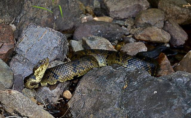
The Shawnee
National Forest office in Illinois announced that "Snake Road" (also
known as LaRue Road 345) will be closed to traffic between mile post 3.0 and
mile post 5.8 during the upcoming annual snake migration, August 30 - October
30. If these coldblooded slitherers don't give you the heebie-jeebies, you can
take a trek on foot to catch the migration which draws observers from all over
the US! Please note, if you head out, some of the species in this migration
have been identified as threatened and endangered by the state of Illinois and
the U.S. Forest Service, so please let nature take its slithery course.
I spoke with
the Shawnee National Forest office today and found that the best time to have a
chance to see see the action is over a sustained period of cooler weather,
lower 80's and 70's, so late September and early October may be perfect
(especially if the leaves are turning). So keep an eye on the mercury if you
want to see the snakes and amphibians as they migrate to their winter
hibernation habitats be sure to take a camera.
You can call
the Shawnee National Forest office for more information at (618) 833-8576 or
read the press release on the Shawnee
National Forest Website.